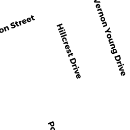
7 VERNON YOUNG DR
Owner Information
TESSIER, WILLIAM W. AND HEATHER
7 VERNON YOUNG DR
PLAINVILLE, MA 02762


Property Details
7 VERNON YOUNG DR is classified as a Single Family Residential (Ranch).
The primary structure on this property was built in 1955. There are 3,271ft2 of built area within this property. There is 1,548ft2 of residential/living space within this property. This property is listed as having 7 rooms.
7 VERNON YOUNG DR is valued at $305,500. The land is valued at $208,000 and the structures are valued at $96,300. There is an additional valuation of $1,200 on this property.
The most recent deed for 7 VERNON YOUNG DR is recorded at the local registrar in Book 33410, Page 128. 7 VERNON YOUNG DR was last sold on Tuesday, August 18, 2015 for $230,000.
Assessment data from fiscal year 2022.
Flood Data
According to the FEMA National Flood Hazard Layer, this property does not appear to be in a flood zone. It may also be in an area not yet reviewed. Nonetheless, confirm this information prior to taking any action.
To view the flood hazards around this property, create a FEMA "Firmette" Map of the area around 7 VERNON YOUNG DR.
Broadband Internet Providers
| Provider | Type | Bandwidth (mbps) | |
|---|---|---|---|
| T-Mobile | Fixed Wireless | 25 | 3 |
| Comcast | Cable | 1000 | 35 |
| Verizon New England Inc. | DSL | 10 | 1 |
| Viasat Inc | Satellite | 100 | 3 |
| VSAT Systems, LLC. | Satellite | 2 | 1 |
| HughesNet | Satellite | 25 | 3 |
| GCI Communication Corp. | Satellite | 0 | 0 |
Broadband service provider data from December 2020.
Adjacent Properties
- 9 VERNON YOUNG DR
Single Family Residential owned by PASSANISI SEBASTINO & LOIS - 10 HILLCREST DR
Single Family Residential owned by WEAVER, FRANCIS & JENNIFER - 8 HILLCREST DR
Single Family Residential owned by FEDERICO, MARY A - 6 HILLCREST DR
Single Family Residential owned by GODFREY, CHRISTINA - 5 VERNON YOUNG DR
Single Family Residential owned by SILVESTRI HEATHER C